Forest Carbon Estimators & Calculators
Forest Carbon Estimators and Calculators
Landowners and foresters may want to know how much carbon their forest is storing and sequestering – whether they plan to explore forest carbon markets or they simply want to know as part of their management decision making. The following no-cost tools provide some options for determining forest carbon storage and sequestration. Please read the disclaimer below before exploring the tools.
Disclaimer:
There are many credible and publicly available models, tools, and calculators for estimating forest carbon in trees or the other forest carbon pools. However, they vary considerably in their ease of use, necessary data inputs, assumptions, and accuracy. For example, some tools will provide an estimate of stored carbon in a parcel of forest that is simply the regional average, while others require detailed field inventory data that can be used to provide a parcel-specific estimate. For field inventory data, different tools require difference amounts of data: some use only tree species and diameter to estimate tree carbon, while others use additional fields like height, decay class, and defects. Those methods that require more detailed field measurements will typically provide more accurate carbon estimates, but the data can be expensive and time-consuming to collect. Before you collect data, it is important to first consider why you want to calculate forest carbon and how you will use the estimates. Then compare your needs to the list of carbon tools and models. When you generate a forest carbon estimate, no matter what tool or calculator you use, there is likely a different method available that will yield a different forest carbon estimate. It is therefore important to know how forest carbon estimates are produced in order to compare forest carbon estimates from one property to another.
Carbon Estimation Tools: A Primer – Before looking into the forest carbon estimation tools and calculators we list below, take a few minutes to read this helpful background Primer on forest carbon estimation tools from the USDA Forest Service.

Simple Basal Area to Tons of Carbon Estimator from the Massachusetts Dept. of Conservation and Recreation
With thanks to William Van Doren, biometrician of the Massachusetts Dept. of Conservation and Recreation, this new carbon estimating tool does so using data from the USDA Forest Service Forest Inventory and Analysis along with the selection of the ecological region subsection in which the forest stand you wish to estimate forest carbon for resides. Follow the steps below to estimate carbon in above and below ground live tree biomass in trees 1″ or more in diameter. The result is in metric tons (1 short ton (2,000 lbs) = .9072 metric tons).
Step 1 – Choose your ecoregion subsection (the numeric/alpha code) from the map below (or click HERE for a PDF that you can enlarge):
Step 2 – Fill in the boxes requiring input (below) to receive your carbon estimates:
Here are some no-cost tool/calculator options for estimating your forest carbon:
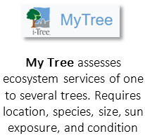
https://mytree.itreetools.org/#/
Analysis of this tool: Uses national averages to calculate tree carbon estimates. Focused on individual trees.
Difficulty of use: Easy
Accuracy: Low
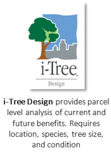
https://design.itreetools.org/
Analysis of this tool: Uses national averages to calculate tree carbon estimates. Focused on individual trees.
Difficulty of use: Easy
Accuracy: Low
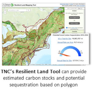
https://maps.tnc.org/resilientland/
Analysis of this tool: This tool created by The Nature Conservancy allows users to explore site-specific estimates of stored forest carbon and average annual rates of carbon sequestration in all forest carbon pools for the years 2010 and 2050. Users can upload a shapefile of a property forest parcel or draw a polygon of the property on the map.
Difficulty of use: Medium
Accuracy: Medium
Analysis of this tool: This tool created by The Trust for Public Land allows users to explore site-specific estimates of stored forest carbon and average annual rates of carbon sequestration on wide geographies and individual properties 100 acres or larger. Data is from LANDSAT imagery and LIDAR with ground truthing.
Difficulty of use: Medium
Accuracy: Medium to High
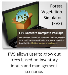
Analysis of this tool: This tool, created bythe USDA Forest Service,requires inputs of site-specific forest inventory data collected on-the-ground. The suite of programs allows for estimation of tree volumes, carbon and the ability to “grow” the forest in the computer model to estimate future volume and carbon. This is a powerful set of models from which to generate estimates of carbon. Requires considerable background knowledge and skill to use.
Difficulty of use: Difficult
Accuracy: High

FIA data access tools
DataMART:
https://apps.fs.usda.gov/fia/datamart/datamart.html
Analysis of this tool: This tool is from the USDA Forest Service and provides Forest Inventory and Analysis inventory data tables in many formats for specific states and geographies. These are pre-generated data that includes forest carbon and other forest related inventory data and information.
Difficulty of use: Difficult
Accuracy: High
Evalidator:
https://apps.fs.usda.gov/Evalidator/evalidator.jsp
Analysis of this tool: This tool is also from the USDA Forest Service FIA and allows for self-generation of forest inventory data output, including forest carbon, for a county or larger area. Options within allow for querying FIA data in areas other than counties or states if coordinates of the polygon are provided.
Difficulty of use: Difficult
Accuracy: High
![]()
https://www.arcgis.com/apps/dashboards/b89f8672ed764331bdfc9e7298cc4691
Analysis of this tool: This tool – using data from the USDA Forest Service Forest Inventory & Analysis, provides coarse woody debris (CWD) carbon values per acre using a map that allows for zooming in and out to select your location.
Difficulty of use: Low
Accuracy: Medium but for CWD only
Additional manual calculation methods are also available to estimate forest carbon. Manual estimation methods require at least a basic understanding of forest carbon, forest measurements, and forest ecosystem dynamics and all methods require careful application and critical thinking to aid calculation and interpretation of results:
Hoover et al 2021: https://www.fs.fed.us/nrs/pubs/jrnl/2021/nrs_2021_hoover_001.pdf
Difficulty of use: Easy
Accuracy: High accuracy for a regional scale; low accuracy for stand-level estimates
Domke et all 2011: https://www.nrs.fs.fed.us/pubs/gtr/gtr_nrs88.pdf
Difficulty: High
Accuracy: High, may underestimate biomass
Jenkins et al 2003: https://www.fs.fed.us/ne/newtown_square/publications/other_publishers/OCR/ne_2003jenkins01.pdf
Jenkins et al 2004: https://www.fs.fed.us/ne/newtown_square/publications/technical_reports/pdfs/2004/ne_gtr319.pdf
Difficulty of use: Medium
Accuracy: Medium-high
Subscribe to our newsletter
Info, resources, tools and tips to support forest landowners, foresters, land trusts and others interested in forest carbon.